Title : Lake Superior - Brule Harbor
link : Lake Superior - Brule Harbor
Lake Superior - Brule Harbor
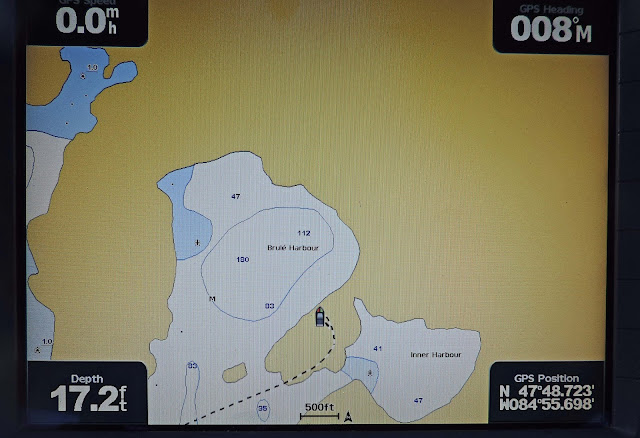
Brule Harbor is actually two harbors - an outer large bay with some protection and 45 -50 deep water in the areas where one could anchor. Then, through a small cut, there is another harbor that is like a lake. Only one small cut could allow winds and waves into the inner harbor. Then, there is a tiny cove in the inner harbor, which was waiting unoccupied for Last Dance.
Waters in this little cove were only 33 feet deep, although quite deep for cruisers who's experience is anchoring in the Bahamas and the Southeast US in depths of 8 - 12 feet. The deeper the water, the longer the required anchor line that must be deployed to maintain the proper ratio (scope) so that the anchor line is pulling on the anchor sideways, causing it to dig deeper, rather than pulling up, causing it to pull out.
With proper scope this cove is much too narrow to swing on the anchor, so two stern lines were run to shore. This arrangement holds the boat in one spot rather than allowing it to swing.
A beautiful day on Lake Superior. This image was made on the island in the cut leading to the inner harbor. In the distance is Lake Superior. The far point on the left is Entrance Island. The two closer points are the inside of the outer harbor, forming the opening to the channel leading to the lake-like inner harbor. The water is much too shallow to pass on the right, looking out, leaving a very narrow cut on the left. The narrowness and the large rocks underwater keep many a boat in the outer harbor.
A ride in the dinghy gives a better perspective of the protection afforded by the cove. It is to the left, in front of the high ridge around the corner from the dark conifer tree in mid shot.
Around that tree and the little rock point, Last Dance can be seen tucked deeply into the cove. In the south this would be called a hurricane hole as it provides great protection from all winds. There are few such places along the eastern shore of Lake Superior.
This view of the chart plotter provides an image of the outer and inner harbors. You can see the blue shoal water that must be crossed to enter the inner harbor, waters that have no depth readings on the chart. The island in the middle of the narrow spot is missing. You can also see that the chart plotter has great inaccuracies, having the boat anchored on top of the rock ridge. Just one of the challenges of traveling on Lake Superior.
The beaches on the mainland and islands that face Lake Superior had a few beaches, again, rock beaches.
There is another area of round rocks on the mainland, south of Brule Harbor. It appears to be a river of rocks running down that is terraced. At the top of the first terrace, a line of driftwood can be seen. This is the height that the waves have pushed the driftwood. How did these round rocks, obviously polished by rough waters become located on high ground appearing to flow like a river?
That is one question for which there is no answer. At the top of this terraced flow of rocks are some pits, obviously dug and rock arranged by humans. First Nation lore has it that the pits were there when the first natives arrived. What humans could have been here before the First Nation People? A walk up the rock river was planned to see the pits, but the rocks are loosely stacked and many moved unexpectedly as they were attempted for footholds. It was decided that the potential for falls and injuries was too high to attempt this journey.
A hike over Entrance Island was more successful. Many types of plant life and rock formations were observed. This shot is looking from the island out into Lake Superior. The lake that can become so angry that it can sink 600 foot freighters like the Edmund Fitzgerald can also be very gentle.
A little fog bank moves into Brule Harbor, another lesson in fog. It is unpredictable and can arrive at any time. The cold waters of the lake (48 degrees was recorded on the chart plotter) cools the air and condenses the water vapor into fog. A small wind shift can create a fog situation. Fortunately, the Last Dance crew had practice navigating in the fog during cruises to Maine. It would be needed.
Thus Article Lake Superior - Brule Harbor
That's an article Lake Superior - Brule Harbor This time, hopefully can give benefits to all of you. well, see you in posting other articles.
You are now reading the article Lake Superior - Brule Harbor with the link address http://objectours.blogspot.com/2017/09/lake-superior-brule-harbor.html


0 Response to "Lake Superior - Brule Harbor"
Post a Comment